"What is time? The shadow on the Dial-
The striking of the clock,-
The running of the sand,-
Day and Night, Summer and Winter,-
Months, years, centuries,-
These are but the arbitrary and
outward signs, the measure of Time,
Not Time itself.
Time is the Life of the Soul".
Longfellow
IN THE BEGINNING GOD
The Christian world has long accepted this statement. There are two general roads leading to this line of thought. One is the accepted authority of the very first verse of the Bible.
The other is through various stages of thought and from Life's own experiences.
These are enlarged by study in many ways and a few of the studies are, astronomy, botany and geology.
The vastness of the study through astronomy makes the Psalmist's exclamation easily understood in VIII Psalm, "When I consider thy heavens, the work of thy fingers, the moon and the stars, which thou hast ordained; what is man that thou are mindful of him, or the son of man that thou visitest him?". Truly the Psalmist reaches the limit of humility when he voices innermost thoughts.
ISLES OF WISCONSIN
Through botany the student arrives at the conclusion that there is but the ONE Life, and that all life, whether plant or animal has but the one source.
Man is part and parcel of the animal life.
Through geology we come to the profound search of the earth's formation and its growth and the wonderful changes that it has passed through to bring it to its present habitable state.
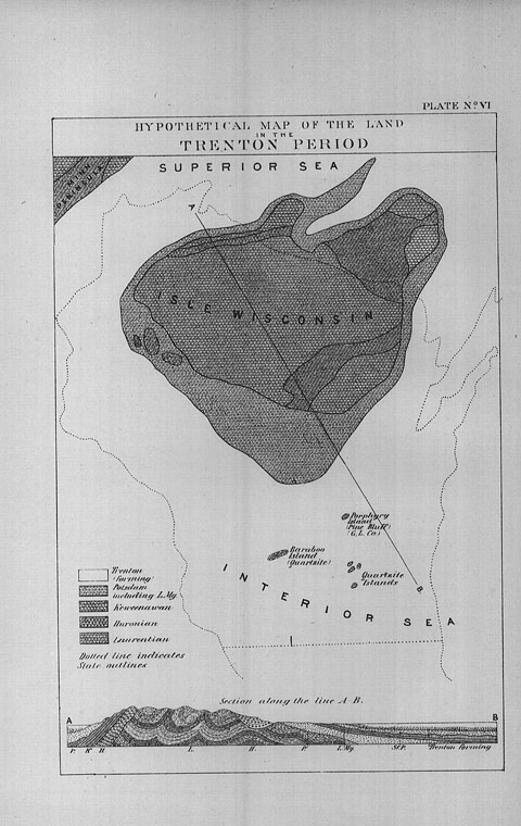
I have selected three illustrations from a work on geology of Wisconsin to illustrate this thought.
The student and artist has pictured his idea of what this state was during some of the formative periods.
The first illustration shows North America under water with but a small portion of the earth visible.
The extreme and limited north area of our state is shown as above the vast ocean of water and it has received the title of "Isle of Wisconsin".
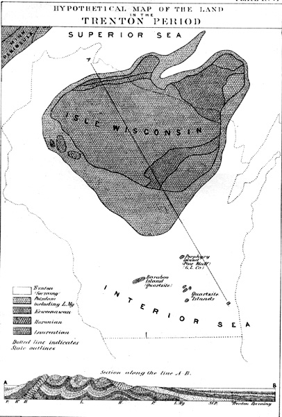
[From Geology of Wisconsin, Survey of 1873-1879, Volume I, Plate VI, facing page 151.]
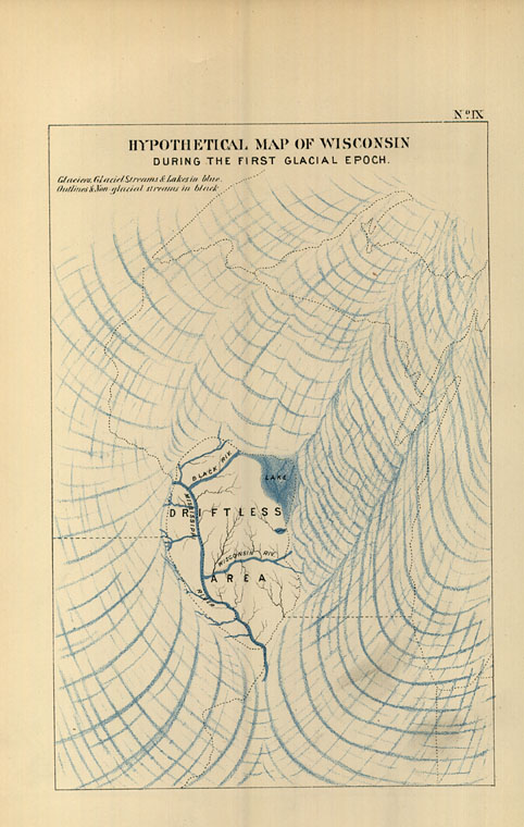
GLACIER WORK
The second illustration shows, during the first glacier period the student's idea of the gouging out the surface of Wisconsin, forming the valleys of part of the river basins of the Wisconsin, Black and Mississippi rivers.
The third illustration, during the second glacier period, is more complete idea worked out showing an extended territory, that formed the valleys of the Wisconsin River and added the Chippewa and Rock Rivers.
Theoretical, of course, but backed by such circumstantial evidence that the mind is obliged to accept its truth.
These slight suggestive references to our existence may stimulate some seeking mind to desire to know more and find vast enjoyment in following of any of the subjects casually suggested in this preface.
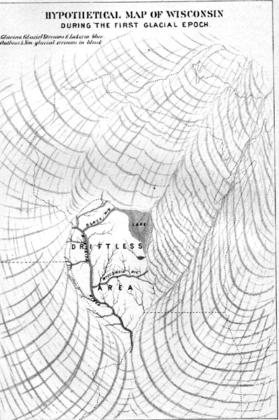
[From Geology of Wisconsin, Survey of 1873-1879, Volume I, Plate IX, facing page 269.]
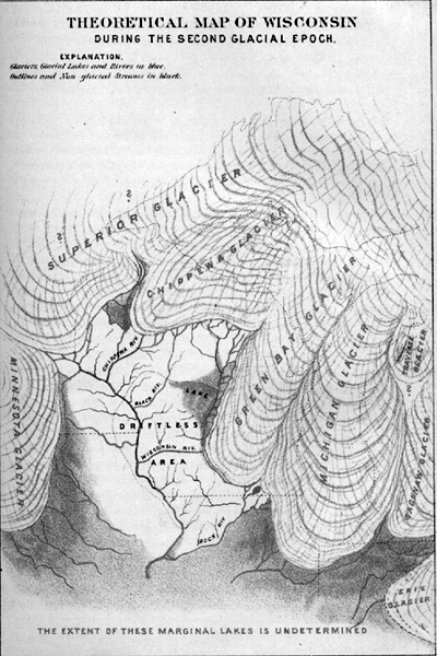
[From Geology of Wisconsin, Survey of 1873-1879, Volume I, Plate X, facing page 272.]
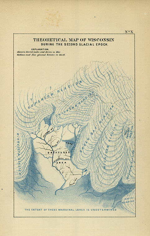
WISCONSIN RIVER
Joliet's large map made by him in 1674 shows a vast territory including Lakes Huron and Michigan and territory west of Lake Michigan.
On that map is marked a river "30" and named "Miskonsing"
This is very close to the Indian name "Wee-Konsan" meaning "the gathering of the waters" on account of the numerous branches.
But this Indian word has no real equivalent in French and the nearest they had to the Indian "wees" was spelled "oui" and pronounced "wee" therefore all French documents carried the name of the river spelled out "Ouisconsin".
There is another interpretation of the Indian word Wisconsin and it is "head has many feeders" having reference to the many streams that form the rise and feed it along the way.
Lake Vieux Desert
Wisconsin River has its source in Lake Vieux Desert, pronounced as if spelled "view desair" with accent on the last syllable.
This lake is on the boundary line between Wisconsin and upper Michigan.
What the name of this lake indicates seems to be a matter of varied opinions. Some call it the "Old Deserted Place".
The Canadian French term seems to mean "old clearing" worked over from the Indian meaning "old land under cultivation".
Doty gave it as "Old Plantation".
The Wisconsin River is about 429 miles long, and from its source flows generally south through the valley, in about the middle of the state, as to east and west, until it reaches Portage where it takes a right turn to the southwest, generally, to join the Mississippi River at Prairie du Chiene
Tributaries
Starting at an altitude of about 1650 feet above sea level, the river drops to a level of 604 feet at its mouth, giving a total fall of 1050 feet with about 635 feet of this fall in the 150 miles between Rhinelander and Nekoosa, first called Point Bausse, This word means to the Indians "Bun-geh-je-win" or "end of the rapids".
The drainage basin of the Wisconsin River includes 12,280 square miles, which is not quite twenty-five percent of the total area of the state.
Among the many tributary streams that pour into the Wisconsin River are Pelican, Tomahawk, Prairie, Rib, Eau Claire, Big and Little Eau Pleine, Plover, Yellow, Lemonweir, Baraboo and Kickapoo, to say nothing about the numerous smaller streams and creeks that feed it.
Profile of the River
From the Wisconsin Survey Bulletin No. 20, on the "Powers of Wisconsin" I take a reduced table of the profile of the Wisconsin River from Kilbourn to Lac Vieux Desert.
Altitude at the mouth is taken as 604 feet, and the various elevations are as follows:
Kilbourn 815 feet
Yellow River mouth 858
Petenwell Bridge 921. 8
Nekoosa, above dam 838. 8
Port Edwards, above dam 958. 5
South Centralia, above dam 971
Consolidated above dam 1004
Biron, above dam 1018
Stevens Point W. C. Rybridge 1066
Jackson Milling Co., above dam 1076. 7
Little Eau Pleine river 1089
Knowlton bridge -ry-1097. 6
Mosinee, above dam 1127. 7
Wausau, above dam 1180
Upper Merrill, above dam 1250. 8
Grand Father Falls head 1385
Tomahawk dam above 1431
Rhinelander, above dam 1558. 5
Lac Vieux Desert 1650
The width of the Wisconsin River varies greatly.
The greater extremes are at the Dells where from a width of 1400 feet in places it narrows down to 20 feet and while at one place it is only 40 feet wide. "At this place the river virtually runs on its edge" with a depth of 45 feet in high water.
The word "Dells" is a contraction from a French word "Dalles" pronounced as if spelled "Dalz", two dots over the "a", and means "a trough".
BOATS ON THE WISCONSIN
In the early days the Wisconsin River was generally navigable from its mouth to Point Boise but the boats usually stopped at the Portage.
From the Wisconsin State Historical reports I take the data of some of the boats.
1835: The steam boat "Enterprise" with Captain Gilbert came up to Dells and tied up in the eddy there over night and then came on up to Point Boise. This boat afterwards made two or three more trips to the same points.
There is but one record of a boat passing through the "Rapids" at Wisconsin Rapids. The Wood County Reporter, a weekly newspaper issued on date of June 2, 1860, has the following;
"SHIP AHOY"
"Last Monday the Steamer "Marathon" passed through the rapids on her way to the Wolf River where she will ply between New London and Shawano. She has been running between Mosinee and Wausau but drew too much water at low stages.
It is the first steamer that ever went through the rapids.
There was no damage done to the boat. Mr. Mc Auley was the pilot. "
The best information obtainable gives this steamer as a stern wheeler but that in going through the rapids they took off the wheel and used oars with which to handle the boat.
It had an upper deck.
From a recent issue of the Sunday Milwaukee Journal I have clipped a picture called "The Ellen Hardy" which was used between Prairie du Chiene and Portage, with the date given as 1875. Page 91.
POLITICAL DIVISIONS
WISCONSIN
Wisconsin was included in the land covered by the Federal Ordinance of 1787 and took the name of the "The Northwest Territory".
Indiana Territory was formed July 4, 1800 with Vincennes as its capital and Wisconsin under that political division.
Illinois Territory was formed March 2, 1810 and all of Wisconsin was included in this new formed division.
Illinois was admitted as a State April 11, 1818 and all of Wisconsin was then added to the Michigan Territory.
Wisconsin at that time consisted of the three counties, Michilimackinac, now in state of Michigan, Brown and Crawford counties and was formed October 1818.
Wisconsin Territory was formed April 20, 1836 and created a State and admitted to the Union May 29, 1848.
WOOD COUNTY
The first Legislature was held at Belmont, Iowa County, Oct. 25, 1836.
One of the first measures passed by this Legislature was to set off 15 counties and among them was Portage of which the present County of Wood became a part.
Joseph Wood, a pioneer of Wisconsin Rapids, was a member of the State Legislature from this district and represented Marathon County as well as Portage.
In March 29, 1856 he obtained the passage of a bill organizing the county of Wood.
The new county was attached to the Seventh Judicial Circuit and Grand Rapids was named as the County seat and under an amendment of September 19, 1856 it was located on Lots 2 and 3 Block 31, Wood's Addition to Grand Rapids provided these lots would be donated to the county.
No action being taken, the act became a dead letter.
Again, in April, 1866, an act was passed by the Legislature locating the county seat on "Fractional Lot 2 of Section 17, of Town-ship 22, Range 6 East at Grand Rapids. While this act required a vote and a donation of the land named in the act there appears to have been no action taken but the first court house in 1866 was erected consisting of a small wooden building on this site. (This location would be between the Sampson Caning Co. at 1251 First St. North and to the river south. See picture page 33.)
By referring to the map of "Grand Rapids of 1874" titles a "Bird's Eye View of the City" you will see in the Index to the Map that No. 1 indicates the Court House and would be as located above.
The first county officers chosen in 1857 were:
County Judge--Joseph Wood
Sheriff--Benjamine Buck
Dist. Attorney--L. P. Powers
Surveyor--H . A. Temple
Clerk of Court--L. Kromer
County Clerk --L. P. Powers
Treasurer--I . L. Mosher
Register of Deeds--L. Kromer
In the "History of Wood County 1923", page 79, at the Library, gives a good account of the Court House.
COURT HOUSE
When the county board of supervisors met for the first time, October 8, 1856, there were but two members, H. W. Jackson and Eusebe Lavigne.
They appointed themselves a committee to select suitable offices and "as the record of the board for January 10, 1856 says; it was ordered that Lavigne's Hall (Magnolia House) be rented for county purposes, with suitable grand jury room, to be furnished by Lavigne for $125 for the first year". Then the account goes on to recite that "At the same meeting, Henry F. Black and H. H. Hecox being now additional members of the board, owing to the setting off of the towns of Rudolph and Saratoga, a resolve was passed that "it was inexpedient for the present board of supervisors to take any action in regard to building county buildings".
This account calling the "Magnolia House" Lavigne's Hall is certainly news to "old-timers". All from whom I have enquired, not one will admit that it was ever Lavigne's Hall, as the Building on that location was always "Magnolia House
This Magnolia House is shown in the picture section and its present location would be that of 840 Washington Avenue on the east side, now the home of A. L. Fontaine. Page 10.
County officers rented such locations as suited their personal feelings or in their own place of business but in February 16, 1867, it was "Ordered that the county purchase from Howe & Rablin the court house in Section 8-22-R6". This was the frame building located as previously indicated and found on the Map of 1874 NO. 1.
Peter N. Christensen was Register of Deeds for many years and his "recollections" in the History of 1923, he recalled that in 1870, Lemuel Kromer, the Register of Deeds and County Clerk, C. O. Baker kept their county office records at their place of business "down town".
When Mr. Christensen took the office of Register of Deeds in January 1881 he kept the records in a room in the office of "Neeves & Neeves" lumbermen, located adjacent to the Wood County Bridge and remained there until the new and present court house was built"
The old court house burned April 25, 1885 and all records kept in there were destroyed. Page 33.
The present Court House was originally built and equipped and first occupied April 25, 1882. Page 21.
It has had several things done to it. Later additions were made to it, and to balance it the entry was taken from the east wing and placed in the center of the tower, as to-day, the top of the tower was at that time changed from a rounding dome to that of several pointed spires and still later, some one thought it would be nice to take that off, because it leaked a little and finish off the tops with what they call a "castellated" wall. Just what relation all the pointed tops of the window arches below it bear to a castle is not clear and the tower has lost some cast as a symmetrical piece of architecture.
GRAND RAPIDS
Grand Rapids was and is the county seat of Wood County. It also was in those early days the chief city on the river and is the oldest town on the Upper Wisconsin River.
From 1866 to 1869 Grand Rapids, remained under town government. On Tuesday April 1st, 1869 the charter incorporating the city of Grand Rapids, was granted by the state Legislature.
The first mayor was Seth Reeves. Under another section in this book will be found a complete file of the mayors of Grand Rapids and Centralia and of the mayors after the consolidation under the name of Wisconsin Rapids.
Change of Name Suggested in 1858
The expensive confusion of names never was more marked than that of Grand Rapids, Michigan and Grand Rapids, Wisconsin, our own town.
It has been necessary in the past for the postmaster and also the Western Union here to file with their respective offices in Grand Rapids, Michigan, a complete and corrected and up-to-date list of merchants and manufacturers and prominent people living here.
Letter and telegrams went to the Michigan city and would never reach here and the truth would only be learned several weeks afterwards. Death messages sent out intended for here would go to the Michigan city and resulted in serious and sad complications.
This seemed to be so very evident that "Jack" Brundage, as his intimates called him, the editor of the "Reporter" wrote his famous editorial way back in 1858. In his February issue of that year he took up the subject and I quote his editorial in full;
"WISCONSIN RAPIDS"
"There is in Michigan a city of some 9000 inhabitants called Grand Rapids which derives its name from the rapids of the Grand River. That city is being continually confounded with this place and letters designed for parties here often have to be remailed from the Michigan, Grand Rapids.
When a person, even in Milwaukee, announces his intentions of going to Grand Rapids, the listener almost invariably infers that it is Grand Rapids, Michigan, to which the speaker is going, and a long explanation of the location of our town has to be given. Even goods, belonging to our merchants, have been shipped to the wrong place, which creates delay and extra expense in receiving them. Now our citizens must do one of two things--either eclipse the Grand Rapids in Michigan in point of population or petition legislature to change the name of this town. -----There is no appropriateness in naming our town "Grand" Rapids. To be sure we have the greatest rapids in the country yet there is no reason why they should be dubbed "Grand". We would humbly suggest the propriety of adopting the title "Wisconsin Rapids". With this name, every one would at once know that our location was in the State of Wisconsin, on the Wisconsin River, an that knowledge alone would satisfy them that our place was no western balloon town. Let us hold a meeting for discussing this subject.
What "Jack" encountered in those days long ago persisted even up to the time the name was finally changed to "Wisconsin Rapids" in 1920. The opposition was just as stubborn in 1920 against changing of the name as it was way back there in 1858, for nothing came of his efforts then.
I do not believe any one living here, when the change was made, recalled this suggestion of Editor Brundage in 1858.
Take the time say 1846 about which Capt. Jos. L. Cotey refers to in his "recollections" in the "History of Wood County 1923".
The town of Grand Rapids lay along the river and one street leading out of it to the east, about at right angles, and was, as now, called Baker Street.
There was no bridge to the west side and the west side, hardly known even as "Centralia" then consisted of but three of four houses and three of these log.
1846 was too early even to have the town boast of but one mill, the "Rablin Mill" at about the present swimming pool and but few buildings of any worth. Only twelve years before Daniel Whitney had just built the first saw mill on the Wisconsin River and located it about ten miles south of town on what he named as "Whitney Rapids" about half a mile up the river from the Nekoosa Edwards Paper Co. dam at Nekoosa. Page 1.
There was no road to anywhere but there was an Indian trail that led from Fort Winnebago up the Fox to Green Bay. All traveling was done on the river.
The population was given by Cotey as 130 males and 17 females which seems nothing but a little hamlet.
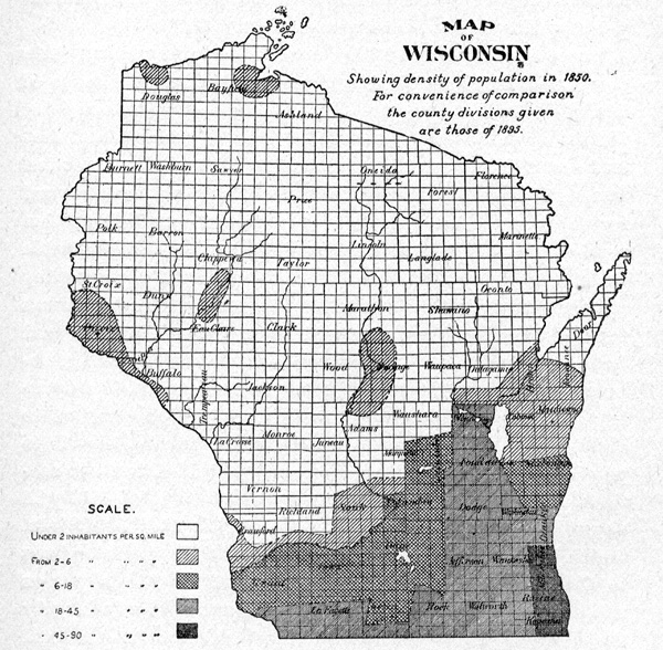
POPULATION
The Title page reads "100 Years of Pictorial and Descriptive History" as if it was but a small part of the selective description of the territory in which we live and taken like a page out of the whole interesting chapter, rather than actually covering the whole period of the localities historical life.
I think we fail, most of the time, to take any sort of mental note of how short a period it has been from the wild life of the Indian's occupancy to our present rather complete period of civilization.
From the bow and arrow to the machine gun, the wild pony to the aeroplane and the Indian pemmican to our packing-house canned meats.
Yet 100 years does cover the whole period of time from the first occupancy by the white man to the year of 1934.
I have clipped three population maps to illustrate this point.
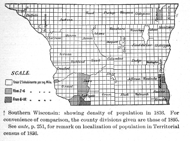
[1836 map. Note: This map isfrom Wisconsin Historical Collections, v.13, p. 332]
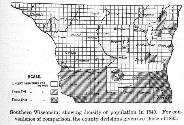
[1840 map. Note: This map is from Wisconsin Historical Collections, v.13, p. 332]
[1850 map]
[Note: This map is from Wisconsin Historical Collections, v.13, p. 334]
These maps bring us to the realization that this is a "NEW WORLD" actually, in which we now live.
One map sector shows the Southern Wisconsin population as of 1836 and that for most part the occupants are placed at less than 2 inhabitants to the square mile. The second map shows the population map for 1840 and our sector still indicated a population less than 2 persons to the square mile.
The third shows as for the whole state and in 1850 Wood and Portage counties are rated as from 2 to 6 individuals to the square mile. To make it more specific, I quote from Capt. Cotey's recollection in the "History of Wood County 1923" where he states "A detailed description of Grand Rapids as it looked in 1846"; he notes that there were but 130 males and 17 females in this district.
In the following table we find that:
| in the year 1870 | Centralia was not taken | Grand Rapids was 115 |
| 1880 | Centralia was 806 | Grand Rapids was 1367 |
| 1890 | Centralia was 1435 | Grand Rapids was 1702 |
| 1900 | Consolidated city 4493 | |
| 1910 | Wisconsin Rapids 6421 | |
| 1920 | Wisconsin Rapids 7243 | |
| 1930 | Wisconsin Rapids 8726 |
This shows that the population has doubled in the past 34 years.
After the treaty with the Indians so that the land along the Wisconsin River could be taken up by the whites then the changes were very fast. Kruikshanks mill at the Rablin mill site changed hands and the partnership of Truesdell-Draper-Kingston and Fay entered the land at "Biron" in 1840 and began the floating of lumber down the Wisconsin River. Widow Fay was not the one to sell the saw mill property at "Biron" to Francis X. Biron, but the successors of the men who entered the land originally and Birons title came from Weston, Kingston and Heldon. Biron bought this in 1846 and a little later, 1853, rebuilt the old mill by practically building a new one.
The mill that Francis Biron left to his estate is shown on page 8 in the Illustrated Section.
In 1841 Daniel Whitney entered the land where the Consolidated stands to-day. He sold this title to Orestes Garrison; bought all the land and power from Whitney on the west side. These powers were three, one Garrison sold to Weller who built the flour mill, then Garrison with others build a saw mill on the next lower power and then he sold Reuben C. Lyon the third and lowest power. This later became the Mack & Spencer pulp mill and electric light plant.
Henry Rablin came here in about 1850 and in 1851 he and Henry Clinton bought the interests who owned the sight where Rablin operated the various mills about where the swimming pool is to-day.
J. J. Kruikshank built the first mill that he sold to Rablin.
John Rablin did not enter into the local picture until after the death of Henry Rablin in 1856. John Rablin was a "Forty-niner" and was a California gold hunter with a vengeance. Mrs. Clara Rablin Nelson has the old pistol Rablin carried and it is so heavy that one of to-day could probably not shoot it with a steady hand. Then she has the leather vest that held $20 gold pieces and this vest he wore next to his body and the imprint of the gold pieces show in the sweat markings through the leather. A similar leather belt was worn by him that had two rows of $20 gold pieces.
George Neeves was one of the earliest settlers and he came to the Rapids in 1839. Joseph Wood, father of F. J. , Geo. N., and Walter Wood was also an early settler and came in 1846. Page 10.
Neeves built a steam saw mill at the foot of Third Street south about at 1350 South Third Street. He held sway at the south end of town and platted much of that part of it. Map page 30.
Neeves was a prime factor in the towns prosperity.
Joseph Wood held sway on the "hill" and the Magnolia House located at the corner of Washington Avenue and 9th Street was a busy center for many years especially in the early days before 1860. It was the "Hotel" of the town then and at one time its courthouse. Mr. Wood was county judge of the first county officers and member of Assembly and succeeded in having Wood County set off and apart by itself where once it was a part of Portage County.
With John Rablin's arrival the town had acquired some size and lumbering and shipping lumber down the Wisconsin River by rafts was the most flourishing business of the river.
Rablin had his part of the town at the north end and much rivalry existed between the three factions of Rablin and Wood and Neeves.
Daniel Whitney, the wonderful personality of this state in its infancy was a most dominant figure. He took great interest in the development of water powers and saw mill properties but cared little about operating them. He owned most of the river at one time either by direct first entry of the land or by purchase after some one else had entered it. Page 4.
After his venture of a saw mill at Whitney Rapids, the Nekoosa of to-day, he came up the river as we found. With him in the Whitney Rapids saw mill, he had sent from Green Bay Ahira B. Sampson who managed the mill several years. Under Daniel Whitney's tutelage Sampson also took interest in taking up claims with the Government.
He and Reuben C. Lyon entered the property that was located at South Side and became the "Hurley town" of early days.
Sampson sold out to Lyon and after Lyon operated a saw mill for some time he sold out to "Hurley & Burnes", see sketch for year 1856.
Hurley & Burnes operated the saw mill for a time and lost it under sheriff sale and John Rablin bought the property in 1869 and to the saw mill he added a pail and tub factory. This he operated until Hopkins, Landauer and Friend, merchants and creditors of Rablin's acquired the properties.
The mills were never operated after that and soon went into decay. Henry Man bought the property of the Milwaukee merchants and he sold it in 1886 to the newly formed stock company the Centralia Pulp & Water Power Company. Page 6
The west side was incorporated in 1856 as Centralia. It was almost isolated as marshes surrounded it except to the south and it had some connection with the mills at Port Edwards. For years this town was called Frenchtown.
It was Sam Grignon who obtained a permit from the Department and entered the land and power site at Port Edwards and named at that time Frenchtown, from the nationality of its inhabitants.
He sold this property to Whitney & Merrill, Daniel Whitney and Samuel Merrill. Daniel Whitney sold his interest to Merrill and in 1841 Merrill sold out to the first of the Edwards line, John Edwards Sr. From then on the property remained in the Edwards family and even to-day his heirs and descendants own the control of the paper company that has mills on the original location of 1840. Page 5.
This became a great feeder to the business houses in Centralia. Henry W. Jackson and George A. Corriveau were certainly the pioneer merchants of the West Side. Corriveau came two years earlier then Jackson did. He is credited with arriving 1852 and Jackson came in 1854.
Henry W. Jackson must have been a very enterprising man. He built the first frame store at about 120 First Ave. So. , that later Nash Hardware Co. tore down to enlarge their building. Page 39.
He associated with Orestes Garrison, who came to Centralia in 1854 also, and R. C. Worthington in a partnership to do a general mercantile business in this store. It evidently lasted less than a year for I find that G. A. Corriveau rented the property in 1857 and remained there many years and possibly did not move from there until he built his own store at the corner of Third Ave. No. and Grand, now the Mead-Witter Block, with street number, 364 W. Grand Ave. Page 38
L. Gross was adventurous enough to build a store farther up street at what would be corner of Second Ave. and Grand on the north side of the Street and would be No. 200 West Grand Avenue. Current opinion at that time, about 1861, was that he was building "way out in the woods". No side walks and mighty poor road. He operated this but a short time and rented it to Orestes Garrison for a store. Lack of but $900 at that time lost this property to Mr. Gross and it was a decided loss, for it was worth much more. But it was several years, in fact 1879 before Corriveau built at the other end of the same block. Page 39.
The City of Centralia was organized March 1874. R. C. Moore was the first mayor. Henry W. Jackson was the first postmaster and appointed in 1854, and continued to hold the office for 21 years, certainly a record.
The Building stood at this original location until torn down in 1924 and the slot in the lower panel of the front was noted as it had always been for the reception of mail when office was closed.
The picture on page 11 gives a good view of this and the other buildings along in that row.
THE ISLAND
This is a local appellation of a part of the city by the early settlers more particularly before the flood of 1880.
The "Bird's Eye View" map shows very clearly a profile of a bridge reaching from the top of the hill on Fourth Street North to the flat below.
Also is marked the pathway of a creek coming from the east of the present Library and passing through a tunnel under it and swinging to the left across the road and following the edge of the hill along market square and crossing Third Street and at one time crossed First Street and going into the river on the extension of Oak on west side of First Street, just north of present Daly's drug store. At the time of the flood of 1880 the river came over the street and across in front of the library location and on down street just as it did in the flood of April 1935.
They planked over the creek where it crossed First and Second Street at Oak, thereby traveling up those streets.
When the city built the city hall at the flatiron between First Street and Baker they first built a stone tunnel for the creek water to run through and then built the City Hall over this.
Later the city diverted some of this water and took it by a large sewer pipe to the river about a block up First Street without allowing it to run under the City Hall. This permitted them to tear out this tunnel under the city hall and get more use from its basement.
BRIDGES
The first bridge to cross the Wisconsin River was on the same site as the present bridge between east and west side or in the early days of things between Grand Rapids and Centralia. Page 13.
TOLL BRIDGE
This first bridge (see picture on page 12) was a toll bridge built by the Wood County Bridge Company.
This bridge was built under special charter granted by the state March 22, 1865. This charter set a time limit to build this bridge was given as May 1st 1866 yet the bridge was not built until 1867.
In its charter provision it gave the bridge company the sole right to build this bridge and provided that no person or persons should have the right to build any toll or other bridge across the river within two miles of the bridge.
The charter authorized the county to purchase same at any time after September 1, 1872.
The county purchased this bridge March, 1873.
The charter provided that the franchise granted the company should continue until the county should make such purchase, when the bridge should become a free bridge.
By and Act of legislature approved March 19, 1873 and published April 1, 1873 the County of Wood was, upon certain conditions specified, expressly authorized to erect and forever maintain a free bridge across the Wisconsin River.
The following is a copy of the Act.
An Act to incorporate the Wood County Bridge Company, and to repeal certain acts.
The people of the State of Wisconsin, represented in Senate and Assembly, do enact as follows:
Section 1. George Neeves, Thomas B. Scott, Isaac L. Mosher, John Edwards Jr. , John Rablin, James Meehan and Orestes Garrison or so many of them as shall accept the franchises hereby granted and their associates and assigns, are hereby created a body corporate and politic, by the name of the Wood County Bridge Company with perpetual succession, and by that name may contract and be contracted with, sue and be sued, answer and be answered, in all courts of this State.
Hold, sell, lease and convey real estate and mixed property to the amount of $70,000 and may enjoy all the right and privelege [sic] incident to corporations, for the purpose of building a toll bridge across Wisconsin River at Grand Rapids, in the County of Wood and of maintaining the same; which bridge shall be constructed from some point in section 17 T 22 R 6E on the east side Wisconsin River, to corresponding point in said section 17, on the west side of said river.
The said incorporators are hereby granted until the first day of May 1866 in which to commence the erection of said bridge and until the first day of September 1867 in which to finish the same provided that the said bridge shall be so constructed as not to interfere with the free navigation of the Wisconsin River or the running of logs or lumber.
Capital stock not exceeding $20,00 in shares of $50 and pay down 10 and balance as called.
Tolls--For any vehicle drawn by two horses, mules or oxen or other animals 25¢, and for each additional animal 5¢ for any vehicle drawn by one horse or other animal 15¢, for single horse with rider 5¢, for horses, cattle, mules in droves exceeding 10 3¢ each, under 10 in droves 5¢, for hogs or sheep in droves 2½¢ each, foot passengers 3¢.
Act approved March 22, 1865.
The county was given the right to purchase this bridge at any time after "5 years from September 1 1867".
In March 1873 the county purchased the bridge for the sum of $10,000 that being the sum fixed by the appraisers, it then became a free bridge.
About 1875 it became unsafe and the county refused to further repair it but was compelled to do so by the court (41 Wis 28) and in 1877 the county rebuilt said bridge a new, of wood, at a cost of about $8000.
The ice swept away the westerly half April 11, 1888 by action of both high water and ice gorges. The bridge was then rebuilt by joint action of the two cities, Centralia and Grand Rapids.
Commissioners were appointed by the common councils of the two cities and they agreed that Centralia's share should be two-fifths and Grand Rapids Three-fifths of the cost.
The new bridge cost $17,400 and was completed in 1889 and was used for over 30 years.
A ferry was again used during the time the bridge was out.
The bridge built in 1889 was of its peculiar construction, of but two spans and so very high, because the financial position of both cities was such that they could not bond themselves for more than would supply this amount of money. The Commissioners were Thos. E. Nash for Centralia and Peter McCamley for Grand Rapids.
These commissioners were well acquainted with the Chicago Milwaukee & St. Paul management and they asked their engineers to assist them in the planning of the bridge. They produced this bridge as being the best of the kind for the amount of money that was available. Several years later the wooden uprights that were in the first bridge became decayed at the footings and a likelihood of danger so they were replaced by all steel construction,
PRESENT CONCRETE BRIDGE
The present concrete bridge (see pictures on page 13) was begun August 9, 1921 and completed June 16, 1922, and the celebration ceremony took place October 18, 1922.
The Wisconsin Highway Commission's office supplying the following information. The bridge is 491 feet long from outside pier to outside pier. The width between curbs is 34 feet and allowing for 8 foot walk on each side gives a total width of about 50 feet between railings. The bridge stands 21 feet and 7 inches above normal water stage to the under side of the highest point under the arch.
The bridge cost $147,523.
The old bridge was sold to Frank Garber for $1100. 00 which was almost giving it away. This bridge should have been retained by the city and placed across from the islands on the east bank to the east shore of Long Island. This would connect the road to Biron with Long Island and now with CCC camps seeking out projects on which to expend both energy and money would have produced for the whole community a beautiful park and resort sites.
FERRIES
For many years there was no means other than roughly built boats and Indian canoes to go from one bank of Wisconsin River to the other. Ferries of all descriptions were made.
Below Point Bausse the Wakelys operated a ferry for many years.
The first ferry that was of any consequence between Centralia and Grand Rapids was built by Eusebe Lavigne.
The Wood County Reporter issue of April 20, 1859 I quote the following:
"E. Lavigne, lessee of the Grand Rapids Ferry, would have the people of the Pinery know that the large boat is propelled by the aid of ropes and pulleys, which guarantees safety and rapidity in all stages of water. This new boat, capable of carrying three teams, is what the people needed and no pains or expense will be spared to render at all times speedy transit across the Wisconsin River. "
This ferry had its Centralia or west side approach on the south end of the island on which the Consolidated has built their office, just a short distance from the north end of the stone bridge where the island has a gradual slope to the river's edge.
The Grand Rapids landing was at the street opening between Herschleb's Bakery and the photograph gallery which would mean now between Street Nos. of 173 and 211 First street north.
The ropes and pulleys he mentions in the announcement were arranged to control the movement of the ferry boat.
First they hung a heavy wire cable from one landing to the other with considerable slack in it.
Then a series of ropes with pulleys attached to the boat and run over this cable.
The swift running of the river was the force that pushed the boat across the river. The front end of the boat would be hauled up taunt on its pulley shortening the distance from the bow of the boat towards the cable and the lower end of the boat let down stream to such an angle that the current would strike on the upper and bow end of the boat and push the boat so it could go on its way down stream and in so doing push the boat out of the way but the ropes to the cable held it to its course so naturally the ferry had to travel across the river. A windlass on the boat regulated the length of front and stern ropes to the pulleys on the cable.
Other ferries had been running at various places on the river without this anchored cable and sometime the currents would be stronger than the ordinary ferryman could pole his way across the river, and the result would be that often the ferry would land far down stream from the place desired.
Wakely ferry below Nekoosa was built about 1840 and operated by the current and cable as the Eusebe Lavigne ferry described.
Nekoosa Ferry Company operated a ferry at Nekoosa with a power drum that controlled the operation of the boat as this was in the still water of the River about a quarter of a mile up river from the dam.
This ferry began its operation in 1906 and continued until the present bridge was built, 1913 (see long strip picture showing ferry in the distance page 71).
The term "Pinery" in Mr. Lavignes notice has passed out of use and "ken" in the language of today. To most of the present generation has little meaning and carries with it no sentiment.
But in the days of real logging and lumber there were hordes of big lumber camps in this state and upper Michigan and Minnesota and a great many men and horses were required to carry on these operations.
Men would sign up to go into the camps late in the fall and stay there all through the winter and come out in the spring either when the logs came "driven" down the numerous streams or camps broke up and man came home on trains.
Usually they went to saloons and gambling houses and in a few days or few weeks at most, all their winter savings would be gone and they would accept most any job until the next "hegira" into camps.
Pine was the only timber that woodsmen would cut in those days.
It carried with it a majesty of occupation as it was connected with one of the Creator's finest wood products and it was beneath a first class woodman’s sense of dignity to cut anything else.
Hence that rather uncertain territory of more uncertain limits became known to the fraternity as the "Pinery".
Hemlock was considered an outcast in the loggers estimation and it was not until nearly all pine was cut or destroyed that hemlock came into use and at no time was it ever even a substitute for pine.
The Pine Man’s contempt for the hemlock product is justified.
STAGE LINE
(PAGE 121)
Aside from boats or horse back and canoes, there was no way out of the central Wisconsin but by stage and these were very limited in number.
In 1873 I find it recorded that the only road at this time out of the section was an Indian trail from Fort Winnebago-Portage, to Green Bay. Otherwise to get from here to Green Bay one took a canoe to the portage between the Fox and Wisconsin and then up the Fox to Green Bay.
The stage coach of the early days was known as the "Concord Coach" and travel was slow and accommodations most limited
The stage left New Lisbon and came up the west side of Wisconsin River. They used a four horse team and the first run was 22 miles to what was known as "half-way house".
In an old historical atlas, I found the "Half-Way House" indicated as being on Section 14 Town of Clearfield, Jackson County.
From Mrs. George Davis I learned that her father L. Gross operated "The Pinery", a large log house and larger barn for the accommodation of the traveling public. There the traveler stayed over night and prepared for the next day’s journey.
This was located north of Necedah possibly eight miles. With the roads very deep of sand and conveyances usually the "lumber wagon" traveling the decidedly tiresome and place to rest was like an oasis to the desert traveler.
This particular stage started from New Lisbon at 6 A. M. and stopped on the way for fresh horses and arrived at Grand Rapids at 6 P. M.
The first wagon road between Grand Rapids and Necedah was opened in 1851. This was the only method of obtaining mail here from then until 1872 when the Green Bay Road came into Grand Rapids.
From the Wood County Reporter issue dated Wednesday December 23, 1857 the following advertisement in copied and reads:
"New Stage Route, from Kilbourn City to Grand Rapids, by the way of Plainville, Point Bluff, Quincy and Strong’s Prairie.
The subscriber having obtained the contract for carrying the mail between Kilbourn City and Grand Rapids, has established a tri-weekly line of stages, a stage to leave each end of the route on Tuesdays, Thursdays and Saturdays. This line will connect with the cars at Kilbourn City.
This route through a pleasant country, on the shortest and best line of public conveyances from Lower Mississippi and Western Illinois to the pineries of the Wisconsin River, and the subscriber will spare no effort to make the accommodations of the route as attractive to the traveling public. Quincy, Dec. 15, 1857.
H. W. Kingsbury. "
In 1857 Myers & Bohnam had stage routes covering the territory from Portage City to Stevens Point by the way of Oxford, Plainfield, Necedah Germantown etc.
RAILROADS
The Green Bay & Western of to-day came into Grand Rapids in November 1872.
The Wisconsin Valley Railway, now part of the Chicago Milwaukee & Pacific Ry. system, was completed into Centralia in June 1873. Page 22.
L. P. Powers, local attorney, was the president of the Wisconsin Valley Railroad Co. Many other local men were interested and Rueben C. Lyon was superintendent of the road construction.
The company received their charter and organized in 1871.
The line commencing at Tomah where it connected with the Chicago, Milwaukee & St. Paul Ry. and extended northeasterly to Centralia and thence on up the "Valley" to Wausau.
The road bed was graded to Centralia in 1872 and rail land and trains came into Centralia in June 1873.
In 1882 it became a part of the Chicago, Milwaukee & St. Paul system.
Under the title of Princeton and Northern Ry. the Chicago & Northwestern Ry. extended its line from Princeton to Marshfield in 1901.
The Port Edwards, Centralia and Northern Ry. was built primarily to open up the timber supply for the mills here and built from Nekoosa through Centralia to Marshfield.
The organization meeting took place January 12, 1890. Its incorporators were John Edwards, W. A. Scott, F. J. Wood, John Arpin, T. E. Nash, G. J. Jackson and J. D. Witter.
The first officers were T. E. Nash President, F. J. Wood Secretary, and John Edwards, Treasurer. It was merged into the Marshfield & Southeastern Ry. and about 1901 became a part of the "Soo" Ry. system.
The Grand Rapids Street Railway was built by local people and was incorporated February 11, 1909. L. M. Nash was the first president and the most active citizen in the organization and continued as its guiding officer until it ceased operation July 1st, 1931.
EARLY SETTLERS
What is now the present state of Wisconsin was a part of the vast territory extending from Detroit to St. Louis and covered by the name of Illinois.
In 1818 Illinois was admitted into the Union as a State, then Wisconsin Territory was joined onto Michigan and Wisconsin Territory as a part of the Union being admitted as a State in May 29, 1848. (Wis. was recognized as a territory Apr. 20, 1836. )
Charles Langlade, with his family moved to Green Bay from Mackinac either late in 1764 or early part of 1766 and established the first white-mans residence in this State.
His history, as given, was related by Augustine Grignon in 1857 in the Wisconsin Historical Notes, and these in turn were related to the Grignons who moved to the Wisconsin River and located at "Grignon Rapids" about six miles below Point Basse.
The first white invaders that came into the lower Wisconsin River territory were lured there by the discovery of lead. Galena is a Latin word meaning "lead ore". This name was applied to the Illinois town of Galena situated in the lead ore section. It was natural that miners should continue their search for lead and the deposits in Wisconsin soon became known to the outside mining world. Hence the miners came up the Wisconsin River from Galena, in Illinois and Dubuque.
The other motive was traffic of furs with the Indians. As this trading became highly competitive quarrels arose and this and the exploiting of’ the Indians attracted the attention of the Federal Government so that it seemed necessary to establish a Fort some where along the territory.
The portage between the Fox and Wisconsin River seemed to be the most logical point and in 1826-8 the United States finally ordered Major Twigg and his young Lieutenant Jefferson Davis, later to become President of the Confederacy, to establish a Fort at the portage and they called it Fort Winnebago.
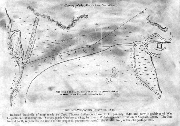
[The Fox-Wisconsin portage, 1839. From Wisconsin Historical Collections, volume XIV, p. 129]
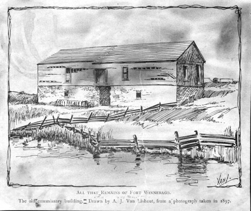
[All that remains of fort Winnebago. From Wisconsin Historical Collections, volume XIV, p. 8]
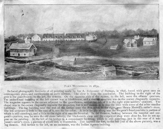
[Fort Winnebago in 1834. From Wisconsin Historical Collections, volume XIV, p. 88]
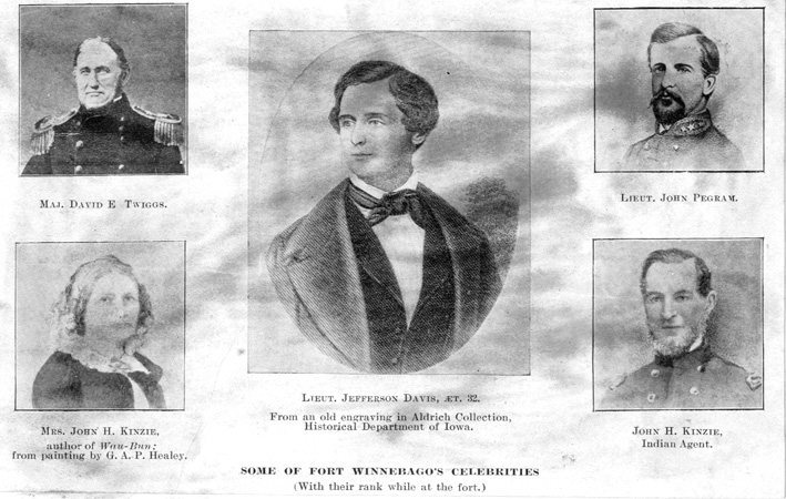
[Some of Fort Winnebago's celebrities. From Wisconsin Historical Collections, volume XIV, p. 109]
The Department had already established a fort at what is now Prairie du Chiene and it was named Fort Crawford, Prairie du Chiene is a French name meaning home of the prairie dogs.
We must keep well in mind that what is now well settled states of New York and Pennsylvania and other eastern states was in the early days of the Colonists, dense forests of pine and hardwood timber.
As lumbering, especially in the pine, slackened in the eastern state for lack of this pine it was perfectly natural that lumbermen should turn their attention to farther western states and venture into them for pine.
So this was the motive that drove the hardier lumbermen and camp followers into the heavily wooded states of Michigan and Wisconsin.
John Jacob Astor of New York organized his "Astor Fur Company" in 1809 and entered into very active and direct competition with the old Hudson Bay Co.
DANIEL WHITNEY
Daniel Whitney was the company’s agent at Detroit, and he had first hand information of the possibilities of the northern Wisconsin region from his trappers and friendly Indians. Page 4.
Daniel Whitney left Detroit and established himself and on his own account entered into business relations with the Indians at Green Bay.
He evidently had further reports of the prospect of pine timber on the Wisconsin River for he obtained some sort of a loose treaty with the Winnebago Indians to cut pine on the Wisconsin River.
Daniel Whitney with his nephew David R. Whitney and a Col. Childs and a small crew of mainly Stockbridge Indians and such outfit of supplies as they could carry took canoes from Green Bay and paddled their way up the Fox River until they reached the portage to the Wisconsin River.
Major Twigg had been advised of their coming and heard somewhat of their intentions and sent word to Whitney not to go up the Wisconsin River and not to cut timber belonging to the Indians.
Whitney and his little party continued on their way in spite of this warning and set up a small saw rig at the mouth of the Yellow River, in the fall of 1827-8
This was when Lieutenant Davis was ordered to take a detail and go up the Wisconsin River and dismantle the mill and confiscate the shingle and whatever lumber there was and order Whitney out of the territory.
It is evident that Whitney did take notice of this order for he returned to Green Bay and entered into a new treaty with the Chiefs of the Menominee, August 16, 183l and obtained an approval from the War Department, Sep. 8, 1831 and came back onto the Wisconsin River and set up the first saw mill on the Wisconsin River at what he named as Whitney Rapids, in the fall of 1831 and winter of 1832.
I wish to establish exactly as near as possible the location of Whitney Rapids and its relation to Point Bosse. In the first place, let us locate Point Bosse. This name is an Indian name and in their tongue it sounds like "Bung gah je wung" meaning the end of the rapids. It is in the middle of Section 15 T 21 R 5 Town of Port Edwards between lots 7 and 8. Whitney Rapids was on Govt. Lot 1 of Section 10 T 21 R 5 and there was but a trifle over a mile in distance between Point Bosse and Whitney Rapids. The present dam and mill at Nekoosa is less than a quarter of a mile below the old location of Whitney Rapids.
The dam lands on Govt. Lot 3 on the east bank of the river and the Nekoosa mill is on Govt. Lot 5 on the west bank of the river.
And it was this "end of the rapids" significance that suggested the limits of the treaty with the Indians in 1836 when they obtained the land that was 40 miles in length "from Point Bosse up Wisconsin River to Big Bull Falls" or what later became Wausau. There are many and various spellings of the word. It has been spelled "Bausse", "Boss", "Boisse" and "Bosse" and the early surveyors in indicating the location have spelled it "Point Bosse" while the old Historical Atlas of 1881 spells it "Point Bass".
Whether Daniel Whitney didn’t know that his treaty with the Winnebago Indian Chiefs wasn’t valid or else he may have thought it would give him at least an excuse for coming into the Wisconsin River territory. This territory did not belong to the Winnebago Indians. It was through a treaty with the chiefs of the Menominee Indians signed at Cedar Point on the Fox River in 1836 between the United States Government and the Indians that the territory from Point Bosse to Big Bull Falls, a distance of forty miles and three miles wide on each side of the Wisconsin River, that opened this section to white man’s invasion.
With Whitney’s treaty approved by the War Department he returned and built, as stated, the first saw mill on the Wisconsin River in 1831 and winter of 1832 and located at Whitney Rapids, the Nekoosa of to-day.
As stated the Chiefs of the Indian Tribes signed the treaty which granted "Daniel Whitney permission to erect a saw mill on the upper Wisconsin River This agreement was approved by the War Department Sept. 8, 1831 and the completed agreement was signed by Daniel Whitney and approved by S. C. Stambough, Actg. Agt. Ind. Affairs dated April 24, 1832".
The conditions of payment to the Indians are related in this agreement as follows: "That after the saw mill shall have been erected, will deliver annually to the Menominee Chief at the mill site on the upper Wisconsin on the month of September for a space of 10 years the following articles estimated at the traders prices at that place to-wit".
100 pounds shot $20. 00
200 pounds flint $ 1. 00
50 pounds tobacco $12. 50
100 pipes $ 2. 00
12 bushels corn $13. 00
5 pounds powder $20. 00
amounting in the whole to $67. 50 per annum"
This is probably as good a place as any and it is probably appropriate to review a somewhat of the history making character of Major Twigg and his Lieutenant Jefferson Davis.
These two familiar persons figured large in the forming of the Southern Confederacy, when Jefferson Davis became President of the Southern Confederacy. Major Twigg was elevated to Brigadier General by the Federal Government and was given command of a very important post in Texas preceding the Secession.
To quote my authority "a large part of the United States Army in Texas was placed under the command of General Twigg, commissary and ordinance, supplies, animals with harnesses, wagons and other property was lost valued at $1,209,500. 00. This was exclusive of the public buildings. For this General Twigg was subsequently dismissed from the army. "
"War Department March 1st, 1861. "
"By the direction of the President of the United States, it is ordered that Brigadier General David E. Twigg be, and is hereby dismissed from the Army of the United States for his treachery to the flag of his country, in having surrendered on the 18th day of February 1861, on the demand of the authorities of Texas, the military posts and other property of the United States in his department and under his charge.
J. Holt
Secretary of War"
AHIRA B. SAMPSON
Mr. Sampson becomes the next interesting character associated with and coming here for Daniel Whitney.
We have noted before that the familiarity of the eastern states like New York with pine lands and timber would naturally make them interested in any territory where reports gave a good account of the quality and quantity of such desirable wealth. Many an ambitious man and boy turned his face to the west in hopes of obtaining either employment or grant of some of the rich lands possible in the "far western states".
Keeseville is a little town located in the northeastern part of New York state and only a few miles from Lake Champlain.
Like our city it is divided into two parts by a river, in this case it is the Ausable.
One part of the town is in Clinton County and the other part is Essex County. In the early Spring of 1827 this young man Ahira B. Sampson, then not over 14 years of age, saddled his horse and with but light equipment started for the "west".
It was reported that opportunities for cheap lands and great demand for labor was the lure that many a young man rose to take, and drew him west.
That age seems exceedingly young to us of to-day, that a boy only fourteen should start on such a journey which could only present dangers and obstacles and alone on horse back. But pioneer life and personal needs did not wait on years in those days. Maturity settled early on young shoulders of both men and women in 1800.
Our adventurer must have owned a very fine horse, not only to make such a long journey through country as wild as that must have been, but because of the desire of the traders to purchase him, on the boy’s arrival in Chicago, his first objective.
He was offered $125 or his choice of any 15 lots into which the little hamlet of Chicago was just then being divided.
Chicago at that time was a scattered collection of rough houses, in a wilderness even greater than young Sampson had traveled through. St. Mary’s Catholic Church was the first church built in Chicago but this was not in existence when Sampson arrived and was not built until the early months of 1833, six years after Sampson drove into Chicago town.
Sampson declined either offer and after a short stay turned his horse’s head toward Green Bay and reached there some time in the summer.
When the records take notice that in 1873, almost ten years after Sampson left New York that the only road out from this territory was an Indian trail from Portage to Green Bay, one can imagine something of the hazards of even horseback travel in 1827.
Whether Daniel Whitney first hired Sampson to go to his Shot Tower at Helena on the Wisconsin River below Portage or sent him directly to Whitney Rapids to manage his saw mill is somewhat of a question. I am inclined to the idea that Ahira B. Sampson and his brother Elisha went to Helena. I quote from Merrill’s Narrative in Vol. 7 of the Wisconsin Historical Collection.
Merrill states "that on his arrival by boat from Erie at Green Bay - then named Whitney as Navarino - he held letters of introduction to Mr. Daniel Whitney".
This brings us to 1834 and he credits Daniel Whitney as then doing as extensive business "reaching on to the Wisconsin River, where he built the first saw-mill upon the river at Point Bausse, some seventy miles above Portage; two large store-houses at the portage, one on the Wisconsin and one of the Fox, a shot tower at Helena. "
From another author of "recollections" the origin of the company that built the Helena tower is uncertain.
"About 1830 a shot tower company was organized under the firm name of Daniel Whitney, Platte & Co. Early in 1836 Henry Teel was hired as superintendent and among the men who worked for him were brothers A. B. and Elisha Sampson, who were employed in getting out window-sash, door frames etc. A. B. Sampson was afterwards employed by Whitney to take charge of his mill on the Wisconsin River, where he worked five of six years after he left Helena in 1837."
This produces a conflict in dates for we have more accurate account of A. B. Sampson coming to take charge of the Whitney Rapids saw mill in 1834. It is evident that Sampson and his brother first worked at Helena and from there went to Whitney Rapids.
When Daniel Whitney started the Whitney Rapids saw mill he placed his nephew in charge but evidently needed some one better acquainted with millwright work so he sent Ahira B. Sampson there it was to act with younger Whitney. In 1838 David Whitney died and this left Sampson in full charge.
He operated the saw mill until 1840 and resigned and moved to Grand Rapids.
In Nov. 9, 1843 Jesse W. Helden entered Govt. Lot 1 of Section 17 in Grand Rapids and August 16, 1845 sold out to A. B. Sampson. On a piece of this land Sampson built a home which he occupied until his death and in which his son Henry Ahira Sampson and family lived until it was sold to the county. The house was in existence 72 years.
Henry Ahira Sampson was born in a log cabin that his father Ahira Sampson built in 1842 and was located on the east bank of the Wisconsin across from the upper end of town of Nekoosa about opposite Block 9 of the Village plat.
Ahira B. Sampson was an active citizen of Grand Rapids and interested in many of the early industries and his name will appear many times in the account of other entries and activities. Ahira B. Sampson died in Grand Rapids in 1885.
From here on there will be no attempt to outline any further pioneer’s history except as they shall appear in the development of some industry or turn of affairs.
POSTMASTERS
I am under obligation to the First Assistant Postmaster General W. W. Howes for supplying the necessary information as to the appointment of postmasters for the separate cities of Grand Rapids and Centralia and also for the ones under the consolidated city of Wisconsin Rapids, Wisconsin
Grand Rapids office was established in the name of "Grand Rapids" in Portage County, January 14, 1845.
| Eliphalet S. Minor first postmaster | January 14, 1845 |
| John Werner | December 12, 1850 |
| Joseph Wood | February 26, 1851 |
| Eusebius Lavigne | August 5, 1854 |
| Lemuel Kromer (in Wood County) | April 14, 1858 |
| Hart B. Philleo | March 29, 1861 |
| Joseph Wood | January 22, 1868 |
| George F. Witter | April 29, 1869 |
| Peter McCamley | October 5, 1885 |
| Frederick W. Burt | December 20, 1889 |
| Edward B. Brundage | December 21, 1893 |
| Albert L. Fontaine | February 15, 1898 |
| Robert A. McDonald | February 20, 1908 |
| Robert Nash | June 2, 1913 |
| Martin H. Panter | November 29, 1921 |
| Albert L. Fontaine | January 27, 1922 |
Centralia Office
| Henry W. Jackson Established | May 18, 1858 |
| Jefferson B. Mitchell | May 27, 1875 |
| Frank Garrison | June 11, 1876 |
| Nels Johnson | March 29, 1881 |
| Lawrence M. Nash | October 5, 1885 |
| Francis L. Rourke | June 18 1887 |
| James W. Natwick | May 17, 1889 |
| Emanuel Mennet | June 19, 1893 |
| William H. Cochran | November 9, 1897 |
| Robert McDonald | June 30, 1902 |
The Centralia office was discontinued May 31, 1904 and all mail went to Grand Rapids.
Under the name of Wisconsin Rapids. Albert L. Fontaine was re-appointed and held until Joseph P. Wheir was appointed acting postmaster September 10, 1934. Joseph P. Wheir appointed postmaster January 8, 1935.
| Mayors of Grand Rapids 1869 Seth Reeves ----Page 10. 1870 L. P. Powers 1871 Joseph Wood 1872-5 J. F. Lunt 1876 Geo. R. Gardner 1877 J. F. Lunt 1878-9 J. N. Brundage 1880-1 C. M. Webb 1882 D. J. Cole 1883-4 I. L. Mosher 1885 G. L. Williams 1886 J. B. Hasbrouck 1887 G. L. Williams 1888 Henry Kuntz 1889 Dr. G. F. Witter 1890 P. McCamley 1891-2 F. J. Wood 1893 T. A. Taylor 1894-5 F. L. Tibbits 1896-7 Geo. W. Baker 1898-9 H. Wipperman |
Mayors of Centralia 1874-5-6 R. C. Moore 1877-8-9 S. B. Coleman 1880-1 R. C. Lyon 1882 L. M. Nash 1883 R. C. Lyon 1884 F. Garrison 1885 N. Gerard 1886 F. Heartel 1887 F. Palmatier 1888-9 W. T. Jones 1890-1 G. J. Jackson 1892 John Schnabel 1893 J. F. Moore 1894-5 Nels Johnson 1896 Dr. A. L. Ridgman 1897-8 F. E. Kellner 1899 Theron Lynn |
Mayors of the consolidated city
1900 B. R. Goggins
1901-2-3 W. E. Wheelan
1904-5 L. M. Nash
1906-7 W. E. Wheelan
1908-9 Dr. F. Pomainville
1910-11 W. E. Wheelan
1912-15 J. A. Cohen
1916-17 E. W. Ellis
1918-21 C. E. Briere
1922-25 O. R. Roenius
1926-31 G. W. Mead
1932-33 Fred J. Whitrock
1934-35 W. T. Nobles
FIRES
July 28, 1865 records a heavy fire and the following buildings were burned. Sampson & Scott, general merchandise; W. J. Balderston Shoe Shop; Gem Saloon; Belanger General Store and Bezallion Blacksmith shop; These buildings were located in Block 13 between Oak and Vine, now E. Grand Avenue, and on the east side of Second St. South.
The Second bad fire occurred September 5, 1867 in Block 31, First St. north. Ramsey Photoshop, H. B. Philleo, Jos. Homier, general store; F. Pomainville, Wisconsin House and Arpin Hall. Loss about $50,000.
Third bad fire was in 1870 in Block 31 at present street Number 210 First St. North. Daly Meat Shop; Warren Cabinet Shop; Cameron Harness Shop; M. C. Worthington Justice of Peace Office. Loss about $25,000.
The fourth bad fire of early days was on March 1873, during a terrible blizzard, so reports read, all the building from Witter House to Herschleb’s Bakery on First Street No. as follows. N. E. Emmons Jewelry; H. B. Philleo, Drug Store; Stowell & Lord Harness; Rablin Hall and W. S. Miller general store. Loss about $40,000.
In June of the same year, 1873, followed which would indicate that it was about between Daly Drug Store of to-day and East Grand Avenue at corner of Second St. South, the Fifth bad fire. Geo. Neeves four buildings, I. L. Mosher Meat Market; T. C. St. Amour Clothing; E. Lableaux Saloon; A. F. Bandeline Cigars; Tim Rouhan Clothing; A.H. Smith Barber Shop and furniture; M. Gordon Millinery, J.D. Lebreche, shoemaker, Wood County Bridge & Building; Tribune printing office. Estimated loss about $25,000.
1873 FIRST FIRE APPARATUS
After the disastrous fire of March 1873 (and also the one in June). Grand Rapids purchased a Clapp & Jones Steam Fire engine with two hose carts and 1000 feet of hose in September 1873.
Mr. C. T. Rogers, general western agent, arrived on Monday for a try out. The engine was placed at the old Ferry landing (near Herschleb’s Bakery) and 200 feet of hose attached. The fuel supply was pine slabs. Coal was so poor it was not used. In 4 minutes after applying match there was 5 pounds steam, 15 pounds in 5½ and in 6½ minutes it was throwing water. The distance was further than guaranteed. The guarantee through 200 feet of hose was 22 feet, and it threw over 25 feet. With 1000 feet of hose out, it was throwing over the cupola of the Rablin House. The investment for the city was $5875.
The First Fire Engine Company meeting held in 1873. A meeting of the citizens of Grand Rapids was held in the council rooms, Wednesday Evening Sept. 17, for the purpose of organizing a fire company. J. N. Brundage was called to the chair and L. B. Warner as secretary. A constitution was submitted by A. H. Butler and adopted, to which the following names were attached.
| A. Baisallion D. Baker Henry Belanger T. Bellamn E. T. Bodette L. P. Boyer F. S. Brazeau Charles Briere A. A. Brundage J. N. Brundage A. H. Butler W. F. Butler Fred Closuit J. Closuit D. J. Cole M. Corcoran J. T. Cotey P. Falk E. F. Foster |
S. S. Harrington C. H. Herschleb Charles Holmes J. Homier J. Ingraham W. T. King Lem Kromer E. Lableaux J. D. Labreche E. Lavigne H. W. Lord H. McClatchie M. J. Mc Raith John Martin Peter Meabey Geo. Moore O. C. Neeves J. H. Pattison Harry Pigg |
W. Pixley F. Pomainville C. Poderville B. Quigley John Rablin Sr. John Rablin Jr. Wm. Roche T. C. St. Amour H. A. Sampson W. J. Smith T. W. Stevensen John Sweeney E. Talmage L. B. Warner C. S. Warren C. R. Wiley George Wood R. C. Worthington [Names alphabetized by editor] |
Officers
Foreman W. J. Smith
1st Assistant T. W. Stevensen
2nd " W. T. King
Hose Capt. A. H. Butler
Asst. " D. J. Cole
Treas. O. C. Neeves
Sec’y. L. B. Warner