For details about a cemetery's location:
View Wood County (Wisconsin) Cemeteries in a larger map
- The Library has a card file of burials that was compiled in the mid 1970s. ask [at] mcmillanlibrary.org (subject: Cemetery%20lookup) ( Email us )requests. HOWGS is compiling an update.
- Open our map. From that map, you can find all the cemeteries,their locations and links to their listings. Driving directions are also available. Or
Click on cemetery name in the list below to open a map showing its location.
- HOWGS (Heart O' Wisconsin Genealogical Society) lookups link to their website and reflect recently compiled records.
- City of Marshfield lookups link to their website and reflect current records.
- McMillan lookups reflect records as of the mid 1970s.
- Some smaller cemeteries have no existing records.
| Name | Township | GPS | Location | Lookup |
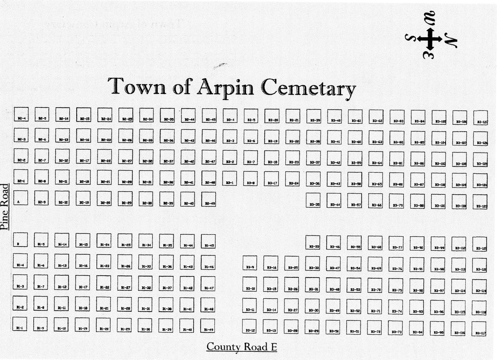
| Arpin (map of cemetery) | Arpin | 44.54375, -90.03922 |
NW Corner of Pine Road and Co. E | HOWGS |
| Emmanuel Lutheran | Arpin | 44.530657, -90.034504 |
On Oak Road, just north of Butternut Road, just south of Arpin | HOWGS |
| Evangelical Free (Swedish Church, North Arpin) | Arpin | 44.557696, -90.03501 |
Richfield Drive, west of Hwy. 186, just north of Arpin. | HOWGS |
| Indian Bill | Arpin | 44.537021, -90.062828 |
Park Road. Take Co. E South from Arpin to Bluff Dr. or follow signs to Powers Bluff County Park. Indian Bill is located near park exit. | No Records |
| John Na-Wee Indian | Arpin | 44.537021, -90.062828 |
Park Road. Take Co. E South from Arpin to Bluff Dr. or follow signs to Powers Bluff County Park. John Ne-Wee is at top of hill. | No Records |
| Greenwood | Auburndale | 44.625481, -90.0072 |
On North Road .5 mile south of HWY 10, on east side of road | HOWGS |
| Norwegian Lutheran (North Auburndale) | Auburndale | 44.649116, -90.073128 |
Corner of Co. M and Y, north of Auburndale | HOWGS |
| Old St. Mary's Catholic | Auburndale | 44.633849, -90.001888 |
One mile north of Auburndale on the northeast corner of Yellowstone and North Roads | HOWGS |
| Slidre Norwegian Lutheran (Sledrie) | Auburndale | 44.615523, -90.054932 |
3 miles west of Auburndale at corner of Mill Creek and Day Roads | HOWGS |
| St. John's Lutheran (Auburndale) | Auburndale | 44.635315, -90.02094 |
Located west of Auburndale on east side of Shady Road, just north of railroad tracks. | HOWGS |
| St. Mary's Catholic | Auburndale | 44.630917, -90.010343 |
Located next to St. Mary's Church, 5866 Main St, Auburndale | HOWGS |
| Trinity Lutheran | Cameron | 44.618089, -90.195179 |
On Hwy 10 one half mile west of Hwy 10/13 junction. | HOWGS |
| Dexterville & Indian cemeteries | Dexter | 44.372582, -90.132179 |
On south side of HWY 54 just west of HWY 80 junction | HOWGS |
| Cruikshank cemetery (extinct) | Grand Rapids | 44.395033, -89.817438 |
On Drake Street at the foot of the hill or at site of water tower (Franklin and 10th) | Extinct |
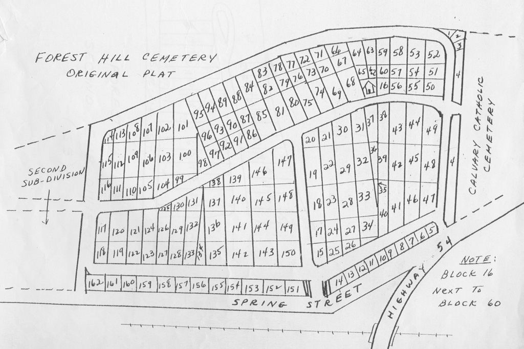
| Forest Hill cemetery (map of cemetery) | Grand Rapids | 44.397425, -89.805422 |
On the east side of Wisconsin Rapids on HWY 54 at Spring Street, just east of the railroad overpass. | McMillan-index |
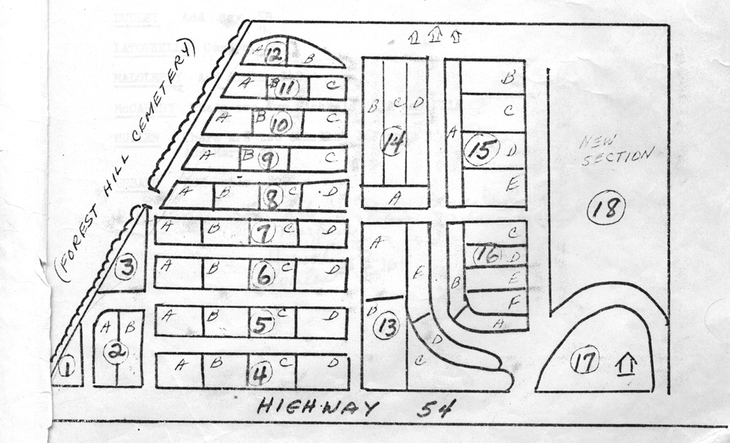
| Calvary Catholic cemetery (map of cemetery) |
Grand Rapids | 44.397425, -89.805422 |
On the east side of Wisconsin Rapids on HWY 54 at Spring Street, just east of the railroad overpass. | McMillan (through mid 1970s) |
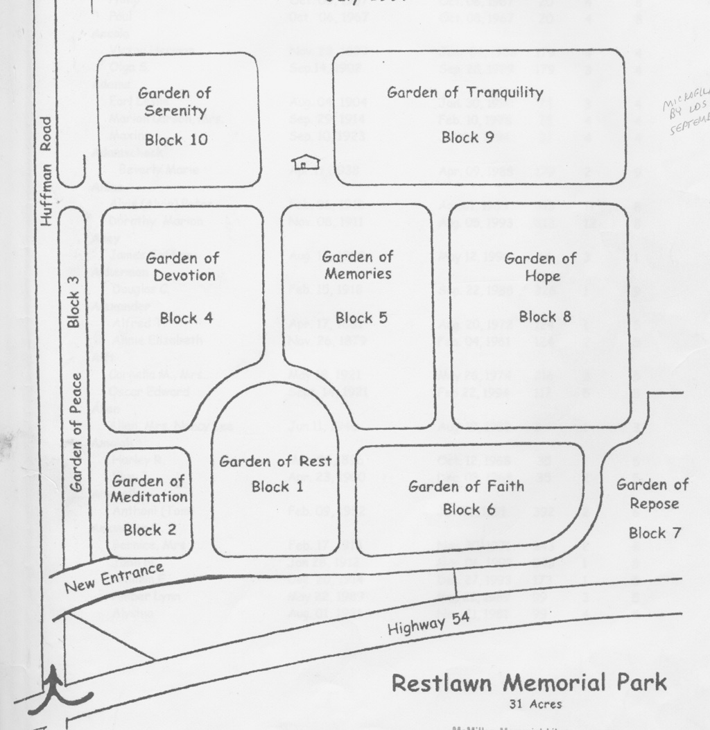
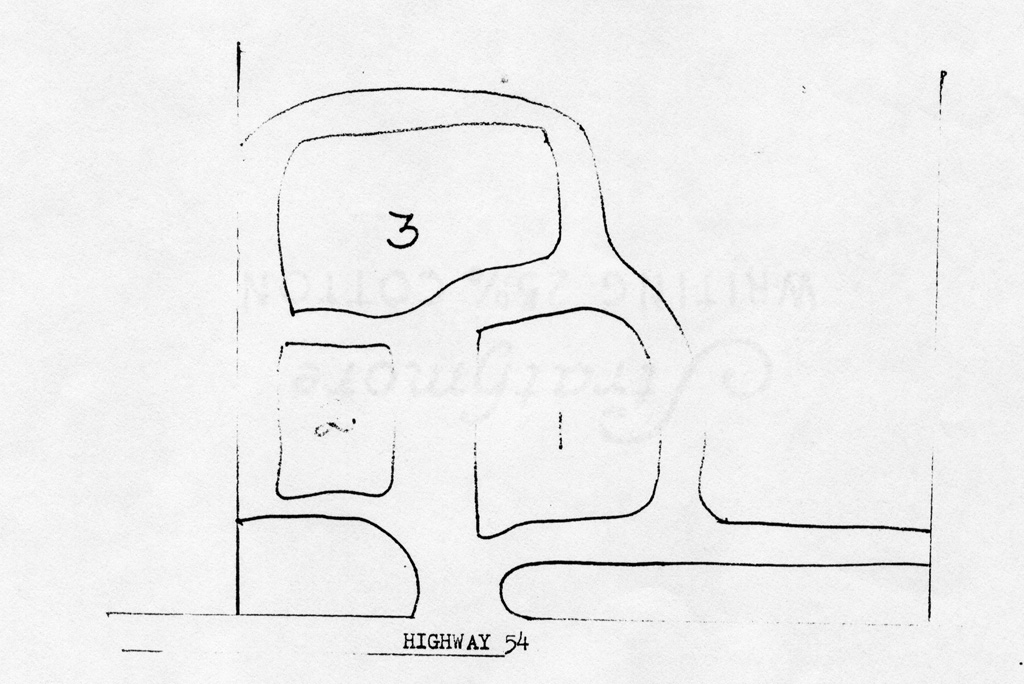
| Restlawn Memorial (map of cemetery) | Grand Rapids | 44.418701, -89.765511 |
East of Wisconsin Rapids on Hwy 54 at Huffman Road | McMillan (through 1997) |
| St. John's Lutheran (map of cemetery), Photos of markers |
Grant Township, Portage County | 44.36436, -89.716845 |
On north side of South Park Road, one half mile east of 80th (Co. U/W) | HOWGS |
| Faith Reformed | Hansen | 44.48579, -89.983778 |
On Birch Street (Co. C) in Vesper | HOWGS |
| St. James Catholic | Hansen | 44.487076, -89.97768 |
Three quarters of a mile north of Vesper on north side HWY 186 near corner of Grant Road | HOWGS |
| St. John's Lutheran | Hansen | 44.442237, -90.104799 |
On Elm Road, 3/4 mile south of HWY 13. | HOWGS |
| Trinity Lutheran (Vesper) | Hansen | 44.485056, -89.975023 |
Take HWY 186 north from Vesper. Turn left onto Grant Rd. Cemetery is on the left. | HOWGS |
| Corpus Christi Catholic | Lincoln | 44.629329, -90.19758 |
On north side of Co. BB just east of junction with Co. B | HOWGS |
| Grace Lutheran | Lincoln | 44.602568, -90.26332 |
Behind church, northeast corner of HWY 10 and Eagle Road. | HOWGS |
| Emmanuel Lutheran (Immanuel Lutheran) | Marshfield/ Hewitt | 44.645575, -90.1126 |
On Yellowstone Road, just west of junction with Co. T (Main Street) | HOWGS |
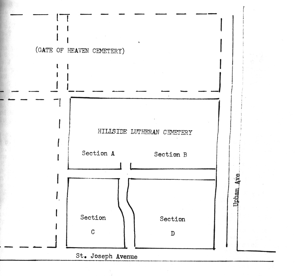
| Gate of Heaven Catholic cemetery (map of cemetery) |
Marshfield | 44.676038, -90.177927 |
Adjacent to Hillside Municipal cemetery | Marshfield City |
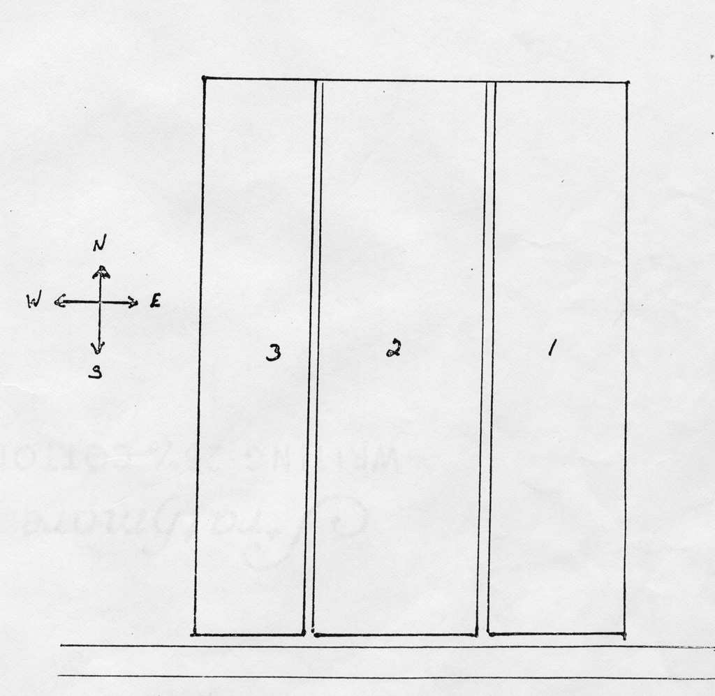
| Hillside Lutheran (map of cemetery) | Marshfield | 44.676038, -90.177927 |
Adjacent to Gate of Heaven | Marshfield City |
| Hillside Municipal cemetery (map of cemetery) |
Marshfield | 44.676038, -90.177927 |
St. Joseph's Avenue in Marshfield | Marshfield City |
| Queen of Heaven | Marshfield | 44.676038, -90.177927 |
Enter between Hillside and Gate of Heaven cemeteries. | Marshfield City |
| St. Michael's Catholic | Marshfield | 44.647162, -90.114841 |
11100 Main St, Hewitt, WI. Cemetery is behind church. | HOWGS |
| St. Killian's Catholic | Milladore | 44.617966, -89.93288 |
Blenker, Wisconsin. Cemetery is behind church. | HOWGS |
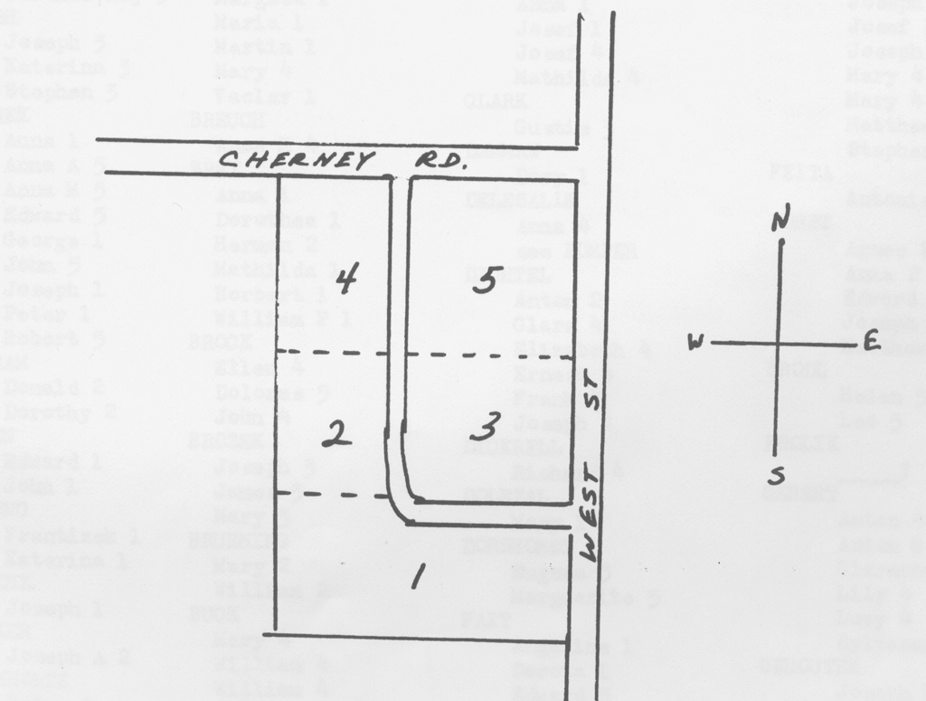
| St. Wenceslaus Catholic (map of cemetery) |
Milladore | 44.60764, -89.854174 |
Southeast corner of West Street and Cherney Road in Milladore. | HOWGS |
| Union Protestant | Milladore | 44.60764, -89.854174 |
East side of West Street between Cherney and 2nd Streets. | HOWGS |
| Civil War Grave (Jones Burial) | Port Edwards | 44.344415, -89.865589 |
On the river bank near former Domtar paper mill | HOWGS |
| Port Edwards Municipal (map of cemetery) |
Port Edwards | 44.348159, -89.908504 |
1.5 miles west of Port Edwards on HWY 54, on the south side of road just after the Moccasin Creek bridge. | HOWGS |
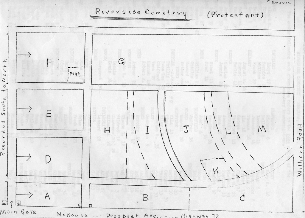
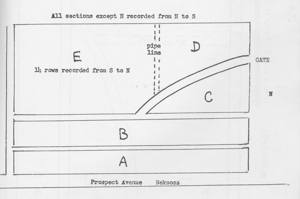
| Riverside cemetery (map of cemetery) |
Port Edwards | 44.32569, -89.892969 |
Prospect Ave (HWY 73) in Nekoosa | HOWGS |
| Sacred Heart Catholic cemetery (map of cemetery) |
Port Edwards | 44.32569, -89.892969 |
Prospect Ave (HWY 73) in Nekoosa | HOWGS |
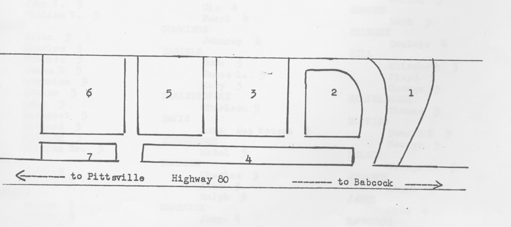
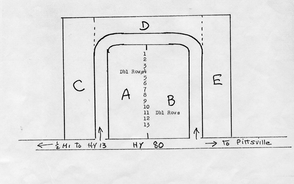
| Remington (Babcock) (map of cemetery) |
Remington | 44.312242, -90.09201 |
On HWY 80 one mile north of Babcock | HOWGS |
| Brooklawn (Brook Lawn Memorial Gardens) | Richfield | 44.595112, -90.160675 |
Corner of HWY 13 and Eisenhower Drive, Richfield Township | HOWGS |
| Far View (Richfield) | Richfield | 44.607457, -90.18178 |
On north side of Co. EE, just east of HWY 13 junction. | HOWGS |
| Richardson Plot | Richfield | 44.599024, -90.13441 |
Section 8, NW 1/4 of SW 1/4. No markers extant. | HOWGS |
| Seventh Day Adventist (Bethel) | Richfield | 44.536592 ,-90.08711 |
On west side of Bethel Road, between Co. N and Weber Drive. | HOWGS |
| Progress | Rock | 44.543505, -90.195351 |
Middle of section 33 | HOWGS |
| Rock Township | Rock | 44.600002, -90.25938 |
Southeast corner HWY 10 and Eagle Road. | HOWGS |
| All Souls | Rudolph | 44.45878, -89.790573 |
Near junction of HWY 34 and Co. C | HOWGS |
| St. John's Lutheran | Rudolph | 44.421889, -89.7933 |
North of Wisconsin Rapids. Take Co. P to Meadowview Drive. | HOWGS |
| St. Phillip's (St. Philomena) | Rudolph | 44.493199, -89.821129 |
West of the corner of Maple Road and 5th Avenue, one half mile south of Co. C | HOWGS |
| Durell Burial | Saratoga | 44.266592, -89.79503 |
Blue Ridge Lane, Section 29, Crystal property. | HOWGS |
| Ensign Burial | Saratoga | 44.263949, -89.795809 |
Section 33 NW 1/4 near Ten Mile Creek | HOWGS |
| Greenhill cemetery (map of cemetery) | Saratoga | 44.296087, -89.87709 |
NE corner of Ten Mile Road and Co. Z, three miles south of HWY 73. | HOWGS |
| Pattee Family | Saratoga | Unknown, maybe Section 26, SW 1/4 | HOWGS | |
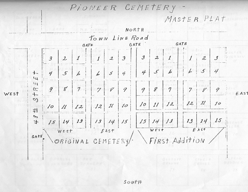
| Pioneer (map of cemetery) | Saratoga | 44.341898, -89.780445 |
Southeast corner of 48th Street South and Townline Road | HOWGS |
| Ross Lake (Indian Mound) | Saratoga | 44.274459, -89.892025 |
Section 26, in SW 1/4 of NW 1/4 and NE 1/4 of SW 1/4 | No Records |
| Anawash (Indian) | Seneca | 44.428386, -89.95571 |
Section 7, NW 1/4 of NE 1/4. From Wisconsin Rapids take HWY 13 to Co. Q. Private property. | No Records |
| St. Joseph's | Seneca | 44.425934, -89.970646 |
On Co. D, three miles south of HWY 13. Behind church. | HOWGS |
| White Indian cemetery (private) | Seneca | 44.402024, -89.911423 |
On Co. Q five miles west of Wisconsin Rapids. Section 7 NW 1/4 | No Records |
| Wood County (Poor Farm) | Seneca | 44.381048, -89.85185 |
On Seneca Road, one half mile west of HWY 54/73 | HOWGS |
| Fairview cemetery | Sherry | 44.596701, -89.913654 |
From Sherry, take Co. F south to Dairy Road. Go west about one half mile. | HOWGS |
| Bethany Lutheran | Sigel | 44.490383, -89.852886 |
On southeast corner of Swedish Road and Co. C. | HOWGS |
| Christian Reformed | Sigel | 44.496016, -89.931507 |
Tenpas Road just west of Co. F junction. | HOWGS |
| First English Lutheran (Bethesda) | Sigel | 44.475196, -89.83263 |
Co. S at Pine Road | HOWGS |
| Frid-Hem | Sigel | 44.497975, -89.862671 |
Corner of Co. C and Lundberg Road | HOWGS |
| Gaulke Plot | Sigel | 44.463681, -89.908333 |
Sigel Township, Section 20 NE 1/4, one half mile north of intersection of Co. HH and Finup Road. | HOWGS |
| Griesbach | Sigel | 44.465764, -89.954166 |
Near corner of Apple and Ruess Roads | HOWGS |
| Holy Rosary Catholic | Sigel | 44.473114, -89.85099 |
On east side of Chapel Road, between Town Hall and Ervin Roads | HOWGS |
| St. John's Lutheran (Sigel) | Sigel | 44.426793, -89.864044 |
Corner of Fisher and St. John Roads in Siegel Township | HOWGS |
| St. Paul's Lutheran | Sigel | 44.455717, -89.948158 |
On east side Co. D just south of junction with HWY 13. | HOWGS |
| Weber/Parkhurst Burials | Sigel | 44.485607, -89.844646 |
Sigel Township, Section 13, SE 1/4 of NE 1/4 | HOWGS |
| Mound cemetery (map of cemetery) | Wood | 44.449039, -90.127845 |
First Avenue (Hwy 80) just south of HWY 13/73 in Pittsville | HOWGS |
| Founders cemetery (Pittsville) | Wood | 44.44671, -90.128274 |
Corner of Jackson Street and First Avenue, Pittsville | HOWGS |
| St. Joachim's Catholic | Wood | 44.446588, -90.130377 |
On HWY 80 in Pittsville, just south of HWY 13 junction. | HOWGS |